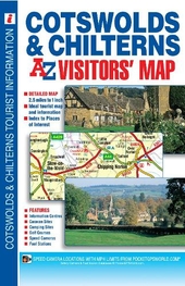
Cotswolds and Chilterns A-Z Visitors\' Map: (New 18th edition)
This map of the Cotswolds & Chilterns is a full colour visitors\' map featuring road mapping that covers an area extending to:*Worcester*Royal Leamington Spa*Northampton*Bedford*Dunstable*London Heathrow Airport*Reading*Newbury*Marlborough*Bath*Bristol*Ross-on-Wye This Cotswolds & Chilterns Visitors\' Map is shown at a clear 2.5 miles to 1 inch scale (1.6 kms to 1 cm) and includes the following features:*Motorways open with full junction detail, motorways under construction and proposed, service areas, primary routes and destinations, A & B roads, gradients 1:5 and steeper, tolls, mileages and national and county boundaries.*Selected safety camera locations with their maximum speed limits and fuel stations.*Selected places of interest, tourist information centres, caravan and camping sites and golf courses. The index is printed adjacent to the mapping and lists cities, towns, villages, hamlets, locations and selected places of interest shown on the map.
£5.95
Similar Deals

Skratch Labs The Feed Zone Cookbook
£21.99
From Tredz

Scrambles in Ulster and Connact Book
£12.99
From Jackson Sport

Pilgrim Paths in Ireland Book
£12.99
From Jackson Sport

The Northern Caminos Book
£16.95
From Jackson Sport

Playboater Handbook II Book
£15.00
From Jackson Sport

Donegal Sligo Leitrim Book
£12.99
From Jackson Sport

Northern Ireland - A Wallking Guide Book
£13.99
From Jackson Sport

Sea Kayak Book
£15.99
From Jackson Sport

