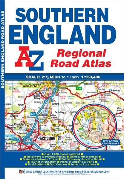
Southern England Regional Road Atlas
This A-Z map of Southern England is a full colour regional road atlas featuring 39 pages of continuous road mapping that covers an area extending to: *Cardiff *Newport *Bristol *Swindon *Reading *Slough *Guildford *Littlehampton *Portsmouth *Isle of Wight *Bournemouth *Weymouth *Sidmouth *Taunton *Weston-Super-Mare This Southern England Road Atlas is shown at a clear 2.5 miles to 1 inch scale (1.58 km to 1 cm) and includes the following features: *Motorways open with full junction detail, motorways under construction and proposed, service areas, primary routes and destinations, A & B roads, selected minor roads, gradients 1:5 and steeper, tolls, mileages, county boundaries, spot heights and hill shading *Selected safety camera locations with their maximum speed limits *Selected fuel stations *National Park boundaries *Selected places of interest, tourist information centres and golf courses Also included are 15 city, town, airport or port plans for: *Bath *Bournemouth *Bristol *Cardiff *Guildford *Portsmouth *Reading *Salisbury *Southampton *Swindon *Taunton *Winchester *Windsor *London Heathrow Airport *Poole Port The index section lists cities, towns, villages, hamlets and locations covered by this atlas.
£5.95
Similar Deals
Save 23%

The Ultimate Guide to Witchcraft: Volume 7
£16.99
£13.20
From Wordery
Save 25%

The Living Well Without Lectins Cookbook
£18.99
£14.39
From Wordery
Save 5%

Grace
£14.99
£14.36
From Wordery
Save 23%

Martin Parr
£30.00
£23.33
From Wordery
Save 24%

Holy Shit
£12.99
£9.93
From Wordery
Save 16%

Rosemary Gladstar\'s Herbal Recipes for Vibrant Health
£11.99
£10.17
From Wordery

Herculaneum and the House of the Bicentenary - History and ...
£22.78
From Wordery
Save 24%

Reset Your Child\'s Brain
£15.99
£12.18
From Wordery

